

Lisbon Coastline Landmarks: A Maritime Travel Guide
- lisbonbyboat
- 2 hours ago
- 8 min read
TL;DR:
Lisbon coastline landmarks showcase the city’s maritime history, with sites like Cabo da Roca and Torre de Belém. Viewing these landmarks from the water reveals their strategic placement and natural scale more clearly than land visits alone. Combining land tours and scenic boat trips offers a richer understanding of Lisbon’s coastal defenses and natural geology.
Lisbon coastline landmarks are historically and geologically significant coastal sites that mark centuries of Atlantic navigation, military defense, and natural evolution along Portugal’s western shore. The most iconic of these sites include Cabo da Roca lighthouse, Torre de Belém, Boca do Inferno, Fort of São Julião da Barra, and Arriba Fóssil da Costa da Caparica. Together, they form one of Europe’s most compelling maritime heritage corridors. Travelers who approach these landmarks from the water gain a perspective that no land-based tour can replicate.

1. What are the most iconic lisbon coastline landmarks?
The Lisbon coast holds a layered story told through stone towers, carved cliffs, and lighthouse beams. Each landmark serves a distinct purpose, from guiding ships safely into the Tagus estuary to recording millions of years of geological time. The sites below represent the full range of what this coastline offers, organized by type and historical role.
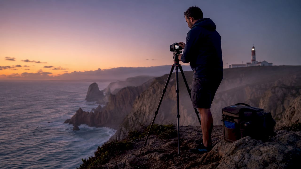
2. Cabo da Roca: Europe’s westernmost lighthouse
Cabo da Roca is the westernmost point of mainland Europe, standing 165 meters above the Atlantic Ocean with a lighthouse that has been operational since 1772. Located 42 km west of Lisbon inside Sintra-Cascais Natural Park, it marks the exact edge where the European continent meets the open ocean. Portuguese poet Luís de Camões described this headland as “where the land ends and the sea begins.” That line still holds.
The lighthouse itself is a view-only site. Public interior access is typically restricted, so plan your visit around the exterior and the dramatic cliff views rather than an interior tour. The real draw is the raw scale of the Atlantic from this height.
The site sits within Sintra-Cascais Natural Park, a protected area with strict access rules
Morning visits offer clearer light and fewer crowds
The nearest town, Azóia, has limited services, so bring water and snacks
Pro Tip: Arrive before 9 a.m. for the best photography light and to avoid tour buses that arrive mid-morning from Sintra and Cascais.
3. Torre de Belém: ceremonial gateway and harbor fortress
Torre de Belém is a UNESCO World Heritage Site built between 1514 and 1520 on the bank of the Tagus River. King Manuel I commissioned it as both a defensive bastion and a ceremonial gateway for ships departing on Age of Discovery voyages. Architect Francisco de Arruda designed it in the Manueline style, blending Gothic stonework with maritime motifs like armillary spheres and twisted rope carvings.
The tower stands roughly 500 meters from Jerónimos Monastery along the waterfront. That proximity is intentional. The Belém waterfront was planned as a maritime corridor where both structures serve as physical and symbolic markers along the river. Walking the route west to east takes about 20–30 minutes and delivers the full historical weight of Portugal’s seafaring era.
From the water, the tower reads completely differently than from the riverbank. Its position mid-river becomes clear, and the defensive logic of its placement at the harbor mouth makes immediate sense.
4. Fort of São Julião da Barra: the Tagus estuary’s first line of defense
The Fort of São Julião da Barra is a 16th-century coastal fortress built to guard the mouth of the Tagus River. Its pentagonal shape, artillery terraces, and layered bastions reflect the military engineering priorities of the era. The fort was occupied during the Peninsular War and served multiple military functions across several centuries.
Lighthouses and forts served complementary roles along this coast. Open ocean navigation relied on lighthouses, while river estuary access and port defense depended on fortifications like São Julião. The fort did not operate alone. It formed an interlocking defensive network with São Lourenço do Bugio, a fort built on a sandbar in the middle of the Tagus estuary, creating a crossfire zone that made unauthorized entry nearly impossible.
Understanding São Julião as part of a system rather than a standalone structure changes how you read the site. The estuary was not just a river mouth. It was a controlled military corridor.
Approach the fort from the coastal road between Cascais and Oeiras for the best exterior view
Combine the visit with Torre de Belém to trace the full defensive line from estuary mouth to harbor
Check local access schedules before visiting, as interior access varies by season
5. Santa Marta Lighthouse: Cascais’s working maritime beacon
Santa Marta Lighthouse in Cascais is one of the most accessible lighthouse experiences on the Lisbon coast. Unlike Cabo da Roca, Santa Marta houses a small museum inside the lighthouse keeper’s cottage, giving travelers a direct look at the daily life of maritime navigation. The lighthouse sits at the edge of Cascais Bay, with views across the Atlantic and back toward Lisbon.
The lighthouse dates to the 19th century and remains an active navigational aid. Its compact scale makes it easy to combine with other Cascais stops, including Boca do Inferno, within a single afternoon. The Cascais coastline packs more Lisbon coastal attractions per square kilometer than almost any other stretch of the Portuguese Riviera.
6. Boca do Inferno: sea-carved cliffs near Cascais
Boca do Inferno, which translates to “Mouth of Hell,” is a sea-carved cliff formation near Cascais that the Atlantic has been cutting into for thousands of years. The site is free to enter and requires about 20 minutes for a typical visit. A short coastal walk from Cascais train station makes it one of the most accessible natural landmarks on the entire coast.
The train from Lisbon Cais do Sodré to Cascais takes about 40 minutes and costs roughly €2.60 one way with a rechargeable card in 2026. That price point makes a full day of Cascais coastal exploration genuinely affordable. Boca do Inferno works best as one stop within a broader Cascais day trip that includes Santa Marta Lighthouse and the Cascais waterfront.
Pro Tip: Visit Boca do Inferno at high tide or during a swell for the full dramatic effect. The cliff arch fills with surging water and the sound alone is worth the trip.
7. Arriba Fóssil da Costa da Caparica: cliffs that record geological time
Arriba Fóssil da Costa da Caparica is a 13 km protected fossil cliff coastline on the southern Tagus estuary with geological records spanning millions of years. Interpretive panels and specialist geological walks run in summer, making it one of the few coastal landmarks in Portugal where paleontology and maritime scenery overlap. The site sits about 30 minutes south of Lisbon by car.
Most travelers skip Arriba Fóssil entirely. That is a mistake. The cliffs connect maritime visitors to a natural history that predates every fort and lighthouse on this coast by millions of years. Cliff-top trails run the length of the protected zone, with beach access points at regular intervals.
Feature | Boca do Inferno | Arriba Fóssil da Costa da Caparica |
Type | Sea-carved arch formation | Fossil cliff coastline |
Length | Single viewpoint | 13 km protected zone |
Access | Free, 20-min walk from Cascais | 30 min south of Lisbon by car |
Best for | Dramatic ocean views | Geology and natural history |
Guided tours | Not typically available | Summer specialist walks |
8. How to plan a maritime-route itinerary for Lisbon’s coastal landmarks
The most efficient approach groups landmarks by geography rather than type. The Belém corridor, the Cascais line, and the Costa da Caparica each form natural clusters that minimize travel time and maximize historical depth.
Belém corridor: Torre de Belém plus Jerónimos Monastery in a west-to-east walking route of 20–30 minutes; add the Monument to the Discoveries for context
Cascais line: Train from Cais do Sodré (40 min, ~€2.60) covers Boca do Inferno, Santa Marta Lighthouse, and Fort of São Julião da Barra in one day
Costa da Caparica: Bus or car south of Lisbon for Arriba Fóssil; combine with a beach afternoon
Cabo da Roca: Best as a half-day trip from Cascais or Sintra; not easily combined with other clusters
Maritime tours add a dimension that land routes cannot provide. Seeing Torre de Belém from the Tagus, or approaching the Fort of São Julião from the water, reveals the defensive logic and spatial relationships between landmarks that are invisible from shore. Travelers who plan a scenic boat trip alongside their land visits consistently report a richer understanding of how these sites functioned together as a system.
Pro Tip: Buy a Lisbon Viva Viagem rechargeable card at Cais do Sodré before your first coastal day. It covers trains to Cascais and most bus connections, saving both time and money.
Key takeaways
The Lisbon coastline landmarks form an integrated maritime system where lighthouses, fortresses, carved cliffs, and fossil sites each play a distinct role in the city’s coastal and natural history.
Point | Details |
Cabo da Roca is view-only | Plan exterior visits only; interior access to the lighthouse is typically restricted. |
Belém is a walkable corridor | Torre de Belém and Jerónimos Monastery connect in a 20–30 minute waterfront walk. |
Cascais clusters efficiently | One train ride covers Boca do Inferno, Santa Marta Lighthouse, and Fort of São Julião. |
Water views change everything | Landmarks like Torre de Belém read differently from the Tagus than from the riverbank. |
Arriba Fóssil is undervisited | This 13 km fossil cliff zone south of Lisbon is one of Portugal’s most overlooked coastal sites. |
What the water reveals that land tours miss
Most travelers walk the Belém waterfront, photograph Torre de Belém from the riverbank, and move on. I understand why. The tower is photogenic from shore, the walk is easy, and the Jerónimos Monastery is right there. But that approach misses the point entirely.
The defensive logic of this coastline only becomes clear from the water. When you sail past Fort of São Julião da Barra and then approach Torre de Belém from the Tagus, you see exactly what a 16th-century ship captain saw. The interlocking fields of fire, the narrowing of the estuary, the way the tower sits mid-river rather than on the bank. None of that reads from a sidewalk.
Cabo da Roca is the same story. Standing at the cliff edge is powerful. But seeing that headland from a sailing yacht, with the lighthouse above you and the Atlantic swells rolling in from the west, gives you a physical sense of why this point mattered to every navigator who ever rounded it. The scale of the ocean from sea level is something photographs cannot capture.
My honest recommendation: do the land visits first. Walk Belém, take the train to Cascais, drive to Arriba Fóssil. Build the historical context. Then get on the water. The second pass, from the Tagus looking back at the shore, is when everything clicks into place.
— Lisbon
See Lisbon’s coastal landmarks from the water with Lisbonbyboat
The landmarks described in this guide look different from the Tagus. Lisbonbyboat offers daily 2-hour sailing tours along Lisbon’s historical coastline, with guides who explain the major monuments and sights as you pass them from the water.

For travelers who want more time on the water, luxury yacht rentals are available for private daily cruises on sailing yachts and catamarans, from 2 hours to a full day. The gallery at Lisbonbyboat shows exactly what these coastal views look like from the deck. If you are planning a trip to Lisbon and want to see Torre de Belém, Fort of São Julião, and the Tagus estuary the way sailors have for centuries, a boat tour is the most direct way to do it.
FAQ
What is the westernmost coastal landmark near Lisbon?
Cabo da Roca is the westernmost point of mainland Europe, located 42 km west of Lisbon at 165 meters above the Atlantic, with a lighthouse operational since 1772.
Is Torre de Belém worth visiting from the water?
Torre de Belém reads as a mid-river defensive structure from the Tagus, which is not visible from the riverbank. A boat tour reveals its original strategic position at the harbor mouth far more clearly than a land visit.
How do I get to Boca do Inferno from Lisbon?
Take the train from Lisbon Cais do Sodré to Cascais (about 40 minutes, roughly €2.60 one way in 2026), then walk the coastal path for about 20 minutes to reach the cliffs.
What makes Arriba Fóssil da Costa da Caparica unique?
Arriba Fóssil is a 13 km protected fossil cliff coastline south of Lisbon with geological records spanning millions of years, making it one of the few coastal sites in Portugal where paleontology and ocean scenery combine.
Can I visit multiple Lisbon coastal landmarks in one day?
The Cascais cluster covers Boca do Inferno, Santa Marta Lighthouse, and Fort of São Julião da Barra in a single day by train. The Belém corridor adds Torre de Belém and Jerónimos Monastery in a 20–30 minute walk.
Recommended
Comments